The WPJ
Residential Real Estate News

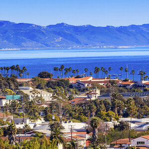
Oddly, Homes in Environmental Hazard Risk Areas in U.S. Appreciated Faster in Last Decade
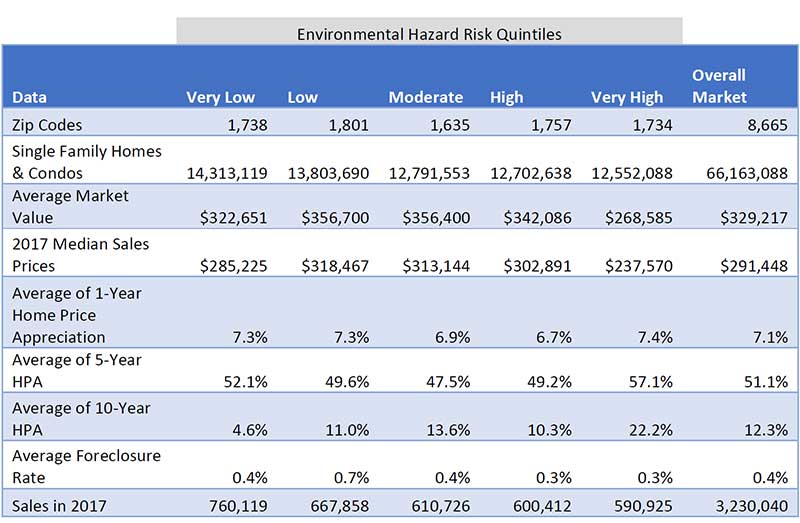
According to ATTOM Data Solutions 2017 Environmental Hazards Housing Risk Index, median home prices in U.S. zip codes in the highest 20 percent for environmental hazard risk appreciated at a faster pace than the overall U.S housing market over the past year, past five years and past 10 years.
For the report, ATTOM Data Solutions analyzed 8,665 U.S. zip codes with sufficient housing trend data for risk related to four environmental hazards: superfund sites, brownfields, polluters and poor air quality.
Median home prices in zip codes in the top environmental hazard risk quintile increased 7.4 percent from a year ago on average (compared to 7.1 percent increase nationwide); increased 57.1 percent from 2012 (compared to 51.1 percent increase nationwide); and increased 22.2 percent from 2007 (compared to 12.3 percent increase nationwide).
"With housing inventory in short supply, even homes in higher-risk zip codes for environmental hazards are in high demand from buyers looking for lower-priced properties and investors looking for the next up-and-coming neighborhood," said Daren Blomquist, senior vice president with ATTOM Data Solutions. "Buyer demand does seem to have a bit of a limit when it comes to environmental hazards, however. Homes in zip codes with superfunds on the EPA's national priority list have seen weaker home price appreciation and have higher foreclosure rates than the overall housing market."
Foreclosure rates lower in highest-risk zip codes
Home foreclosure rates in zip codes in the highest quintile for environmental hazard risk were slightly lower at 0.3 percent of all homes with a mortgage than in the overall market -- 0.4 percent.
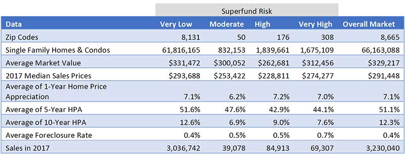
Superfund risk was the exception. The home foreclosure rate in zip codes in the highest risk category for superfund risk was on average 0.7 percent, more than 1.5 times the overall market foreclosure rate of 0.4 percent.
Highest-risk zips for superfunds post weaker price appreciation, higher foreclosure rates
Of the four environmental risk factors analyzed in the report, Superfund risk was the only factor where home prices in the highest-risk zip codes appreciated at a slower pace than the overall market. Median home prices in zip codes with Very High Superfund risk increased an average of 7.0 percent from a year ago (compared to 7.1 percent nationwide), increased an average of 44.1 percent from five years ago (compared to 51.1 percent nationwide) and were up an average of 7.6 percent from 10 years ago (compared to 12.3 percent nationwide).
Houston, Riverside, Portland markets with most combined home value in highest-risk zips
A total of 12.6 million U.S. single-family homes and condos with a combined estimated market value of $3.4 trillion were in zip codes in the top quintile for environmental hazard housing risk. The average market value of those homes was $268,585 compared to an average market value of $329,217 for all 66.2 million U.S. single family homes and condos analyzed for the report.
Markets with the most combined value of homes in zip codes in the top quintile for environmental hazard risk were Houston, Texas ($415 billion); Riverside-San Bernardino, California ($344 billion); Portland, Oregon ($254 billion); Washington, D.C. ($161 billion); and Chicago, Illinois ($134 billion).
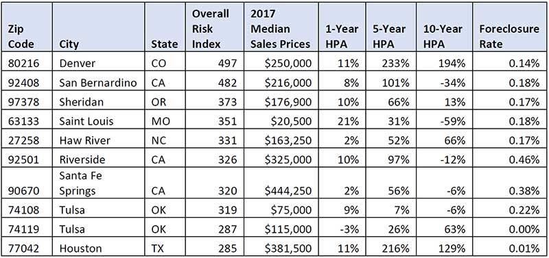
Top 10 zip codes for overall environmental hazard housing risk
Zip codes with the 10 highest total Environmental Hazard Housing Risk Index values in 2017 were in Denver, Southern California, Portland, St. Louis, Burlington, North Carolina, Tulsa, Oklahoma and Houston.
Real Estate Listings Showcase

This website uses cookies to improve user experience. By using our website you consent in accordance with our Cookie Policy. Read More